Milestone
$19B
Citywide damages and lost economic activity from Hurricane Sandy

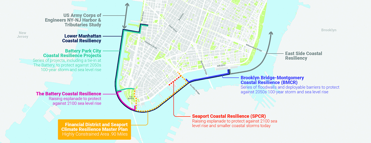
The Financial District and Seaport Climate Resilience Plan is a joint effort led by New York City Economic Development Corporation (NYCEDC) and the Mayor’s Office of Environmental Justice (MOCEJ) to transform the waterfront, creating a place that better serves current and future generations of New Yorkers. The Master Plan, which outlined a conceptual design for protecting Lower Manhattan from sea-level rise and coastal storms, was released in December 2021. Since the release of the conceptual design, the design has continued to be advanced and refined to respond to stakeholder needs, technical constraints, and regulatory considerations.
Citywide damages and lost economic activity from Hurricane Sandy
NYC is increasingly vulnerable to flooding due to climate change. More intense coastal storms, rising sea levels, and extreme precipitation are already causing flooding across New York City. By the 2040s, Lower Manhattan’s shoreline will begin to experience frequent tidal flooding from sea-level rise, impacting streets, sidewalks, buildings, and critical infrastructure.
In 2012, Superstorm Sandy caused catastrophic damage across the five boroughs, including Lower Manhattan, claiming lives and damaging thousands of buildings and key infrastructure. The city’s stormwater system was overwhelmed and subway repairs continued years after the storm.
In 2021, back-to-back storms Tropical Storm Henri and Hurricane Ida broke rainfall records, flooding homes and transit systems. That same summer also saw 17 days above 90 degrees, a sign of intensifying extreme heat. These trends are accelerating; sea levels have already risen one foot since 1900 and could rise up to five feet by 2100.


Lower Manhattan plays a critical role in New York City’s economy, serving as one of the largest business districts in the country. This economic powerhouse fuels the city and the region at large, making it indispensable to New York’s overall vitality. Additionally, as a major transportation hub, Lower Manhattan provides connections across all five boroughs and the tri-state region through a robust network of subways, ferries, roads, and bike paths. Millions of people travel through Lower Manhattan by rail, bus, car, and ferry every day.
Lower Manhattan is also more than just a business district—it’s a regional center of culture, community, and civic life with a growing residential community and a destination for students and visitors. In recent years, Lower Manhattan has seen a transformation into a vibrant, mixed-use community. With a 170 percent increase in its residential population over the past two decades, it now offers amenities for residents, students, workers, and tourists. This evolution has made it not just a place to work or commute through, but a thriving neighborhood that meets the needs of a growing and diverse population.
Lower Manhattan by the Numbers
Annual visitors

Estimated tax contributions

Daily subway, PATH train, and ferry riders

Annual visitors
Daily subway, PATH train, and ferry riders
Estimated tax contributions
If no action is taken, repetitive flooding is projected to cause up to $20.3 billion in estimated cumulative total losses to the region by 2100. While this represents a tremendous economic impact, it still does not take into account many other costs that are challenging to quantify, including losses to citywide services from subway, electrical, and stormwater infrastructure.
The FiDi-Seaport Climate Resilience Plan is part of the Lower Manhattan Coastal Resiliency (LMCR) strategy, a citywide initiative to prevent Lower Manhattan from flooding. As of 2025, the City has advanced over $1.9 billion in LMCR capital projects. Most of the LMCR projects are under construction or will soon complete design. The segment between The Battery and the Brooklyn Bridge presents a unique challenge and is the last remaining gap in the LMCR strategy. The concentration of subway tunnels, historic assets, active ferry terminals, and constrained waterfront space make traditional flood-protection approaches difficult. The FiDi-Seaport Climate Resilience Plan will close the gap and, when complete, contribute to a comprehensive flood-protection strategy for Lower Manhattan.
Receive our emails with updates and event invitations.